A major part of our project is understanding the significance of Cades Road(Margary 80a), the eastern twin of Dere Street running north/south through the Vale of York.
Often in focusing on a defined historical period for research, it is easy to become out of sync with that which went before and after. Most will have heard the urban myth of the A1 being on top of Dere Street on its route through North Yorkshire and Durham, but is that actually true.
The Roman road Dere street is a Roman military road hugging the eastern side of the Pennines through our research area, transecting the entrances to the upper Yorkshire and Durham Dales.
After leaving Catterick on the Swale and passing Scotch Corner the start of the east/west route across the Pennines, Dere St leaves the alignment of the modern A1, and slowly begins its climb to an elevation of upto 260m as it moves increasingly west.
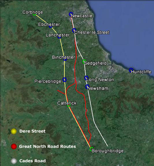
The road connects a series of Roman forts in west Durham, Piercebridge on the Tees, Binchester on the Wear, Lanchester on the Browney, Ebchester on the Wear, arriving at the major Roman supply depot at Corbridge on the Tyne, centrally positioned to supply forts on Hadrians Wall both to the west and east. Was it built to create a line of forts, controlling the high Pennines, or to protect a strategic supply route. Perhaps in reality it was a bit of both.
Dere St- Great North Road- Cades Road
It would appear once its military purpose ended in the early 5th century, whilst probably remaining in use as west Durham local road, the next time we see the road as a published route in the medieval period, where it is recorded only as a route to Scotch Corner for access to the east west route across the Pennines.
To the north of Scotch Corner,, the focus of medieval settlement is in the productive lowland areas and coastal plains, and the strategic routes followed. On a purely practical level as a strategic route, the course of Dere Street in Durham was always a road to knowhere, once Hadrians Wall went out of use, subject even today to winter inaccesibility, and once north of Hadrians Wall a journey to Scotland would have required navigating across the equally inhospitable and at times inaccessible high Cheviot border country.
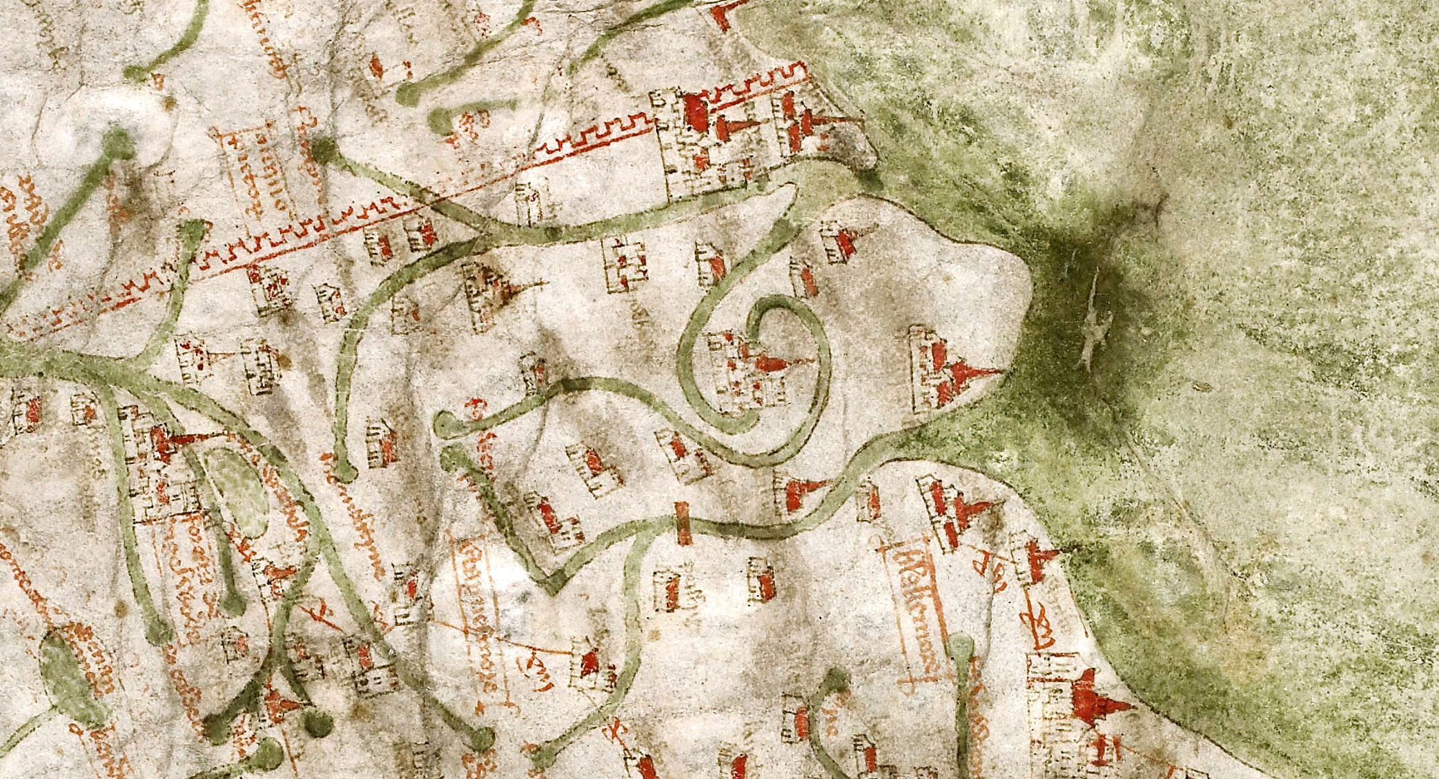
Gough Map 1360
What is interesting is that if we take the Yorkshire stretch of Dere Street, and the Durham stretch of Cades road, join them with a wibbly wobbly bit of the Great North Road, and we end up with the A1 route pre-motorway upgrades
I would now like to introduce an excellent piece of unpublished research on the Great North Road by Hugh Gillespie.
I bumped into his website by accident which has a selection of chapters available online to read. I approached Hugh who kindly provided me with the chapters relating to Yorkshire and Durham, and gave me permission to publish them on the blog. They offer a fascinating insight into the development of the modern road system. Of particular interest to me is the reality that the link between Dere Street the Great North Road and the A 1 is quite recent in historical terms, contrary to what many of us believe, as recently as the 1920’s when the road system was named, the road we know as the A167 Topcliffe to Darlington road through Croft was actually designated the A1 for two years before it was transferred to Leeming Lane which we know today as the A1.
Pountey’s Bridge and the Tees crossing point of Cades road is the classic chicken and egg scenario. An enigmatic roman road lost to history needing a crossing point, and a bridge looking for a road to cross it, put the two together, a touch of imagination and everything is a possiblity.
Pountey’s is but one manifestation of the name which simply means Pons(bridge) and teys(Tees). Bridge of the Tees.
The earliest name and reference is circa 1200, and with Leland failing to mention it in the middle of the 16th century it would seem by his time it had already gone out of common use. Perhaps a more accurate indicator of its demise, can be gleaned from the known presence of a hermitage on the bridge under the control of the prior of Durham, who made the last appointment to this hermitage in 1426, after which there is no further reference
That there was a bridge at Middleton One Row there is no doubt, and a bridge that seems to pre- date the bridges at Yarm built by Bishop Skirlaw in about 1400, and the current bridge at Croft also built in the 15th century to replace the earlier wooden bridge destroyed by floods. The question is what evidence is there for linking Pountey’s bridge to the Roman period as a crossing point of Cades Road(Margary 80a), and when was the link made.
Cade’s Road(Margary80a) is named after John Cade of Gainford, an 18th-century antiquarian who in 1785 proposed its existence and possible course from the Humber Estuary northwards to the River Tyne, a distance of about 100 miles (160 km). Although evidence exists for such a road on parts of the proposed route, particularly through North Yorkshire, there is considerable doubt regarding its exact course and where it crossed the Tees. The road’s Roman name is unknown, although Cade referred to it as a continuation of Rycknild Street.
Cades route begins at Brough-on-Humber the site of a ferry, a Roman fort and civilian settlement (Petuaria) alongside a major Celtic settlement. He suggested that it ran northwards through Thorpe le Street and Market Weighton, before gradually turning westwards (possibly following the line of another Roman road) until it reached York (Eboracum). From York it continued northwards, skirting the edge of the Hambleton Hills towards Thornton-le-Street near Thirsk, and then north just to the west of the massif of the North York Moors. Approaching the Tees the 12km extant alignment of hedgelines and country lanes evaporates into thin air just 800m from Fardeanside Ford a crossing point into Newsham in the parish of Egglescliffe one of the principal crossing points of the Tees, even after the building of the road bridges at Croft and Yarm. After crossing the Tees Cades route takes the road north to Sedgefield, Durham, Chester le Street, before finally terminating at Newcastle.
Cades Road looking south from the Tees
It is at this point on Cades deliberations, where common sense and logical thinking seem to have left the building, in preference for the if’s, but’s and maybe’s of antiquarian thought.
John Cade was a local man from Gainford, and the area along the 100 mile route he knew most intimately was where he was now trying to solve a conundrum. Accepting that he was party to the view that Roman roads were generally straight between given points reflecting the topography of the landscape, logic would have suggested that crossing the adjacent ford, would allow the route to continue in a more or less straight line towards the point where the route becomes evident in the landscape again at Sedgefield. The problem for Cade was that a crossing at the ford was not supported by evidence of archaeology, no Roman camp, no earthworks, and perhaps more importantly no clearly defined straight alignment to the north.
Did Cade therfore jump at Pountey’s bridge as his crossing point?
Well no he didn’t!
Cade didn’t choose Pountey’s because he presumably knew that in 1785, there were numerous mentions of Pountey’s bridge as being medieval, it was not until the 1820’s, that for the first time the bridge is mentioned as Roman.
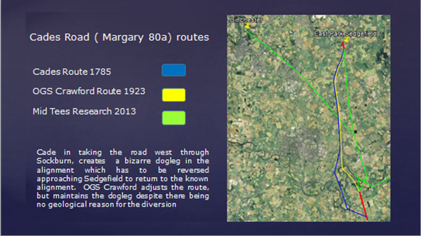
Cade also had another candidate, just 2km to the west in the longest loop of the Tees that extends some 4.5km from the median line of the river south into the North Riding of Yorkshire lay the ancient site of Sockburn(Soccieburg). A defended ancient site by its name elements, the site where all the new Prince Bishops would formally enter the county of Durham, the site of the famous Sockburn Worm legend, an ancient church with Viking hogbacks and Anglo Saxon crossshafts aplenty. Sockburn, together with maps already ancient by 1785 showed a road north out of the peninsula joining with the straight road north to Sadberge at Middleton St George. Cade presumably had enough circumstantial dots in his mind to join them up and neatly extrapolate the site at Sockburn back to the Romans. In doing so Cade forced his alignment 2km to the west of its route through North Yorkshire creating a dogleg. A single dogleg is perhaps not a problem, and is common on roman road alignments, the problem for Cade was that as he approached Sedgefield, he had to force the road back to the East by 2km to return to the alignment in East Park. This diversion created a double dogleg, with not a pimple in the landscape to justify it, clearly against all the engineering practices common to the laying out of a roman road alignment.
Perhaps we should not be too hard on John Cade, he was after all working without the modern benefits of good maps and aerial photographs., we can perhaps be less generous with those who came later.
To anybody considering field research in archaeology, the logic of Cades double dogleg is a perfect archaeological example of putting two and two together and making five. However Cades alignment set the baseline of the alignment, which in major part survives to this day. Cades route was subject to criticism within a few years of him publishing it, but it was nearly 150 years before an alternative alignment at the Tees was suggested by OGS Crawford of the Ordnance Survey.
In the early 1920’s, probably based on 100 years of local folklore and surrounding the romanisation of Pountey’s bridge in the 1820’s, OGS Crawford suggested an alternative alignment. The intervening century had generated claims of a motte north of Pountey’s being a Roman camp, with perhaps another Roman camp at Sadberge in the ‘roman’ field, he needed to look no further than Pountey’s Bridge. Without any more actual evidence than Cade, he suggested the road continued in a NNW direction and crossed at Pountey’s, before returning to Cades alignment. Crawford although reducing the dogleg to the west slightly, like Cade did not address the return dogleg approaching Sedgefield,
Despite the passing of 250 years since Cade, and despite numerous investigations, no evidence of Rome has been found at Sockburn or Pountey’s or on the alignment upto Sedgefield, apart from a few random finds.
Subsequently Crawfords route, including Pountey’s was adopted wholesale by Margary in his definitive book on Roman roads, but still nobody questioned the bizarre logic of the doglegs, whilst 800m away across a simple ford, hiding in plain view was a Roman military site and settlement on the north side of the river, opposite the confirmed southern alignment, and exactly where logical thinking, topography, strategic value and common sense dictated it should be.
Cades Road Alignments
As the specialised divers in the amateur Northern Archaeology Group , we led an investigation at the site of Pountey’s Bridge, with the aim of locating any remaining structure, and hopefully dateable artifacts to support the argument that Pountey’s was Roman.
Bob and I first got interested in Pountey’s Bridge in early 1991. This was due to the diligence of a Billingham historian called George Preece, who devoted many hours researching the subject. George told us that the bridge foundations were still visible in the river in 1823, and asked if we could locate them. He had already secured permission from the land owner in advance.
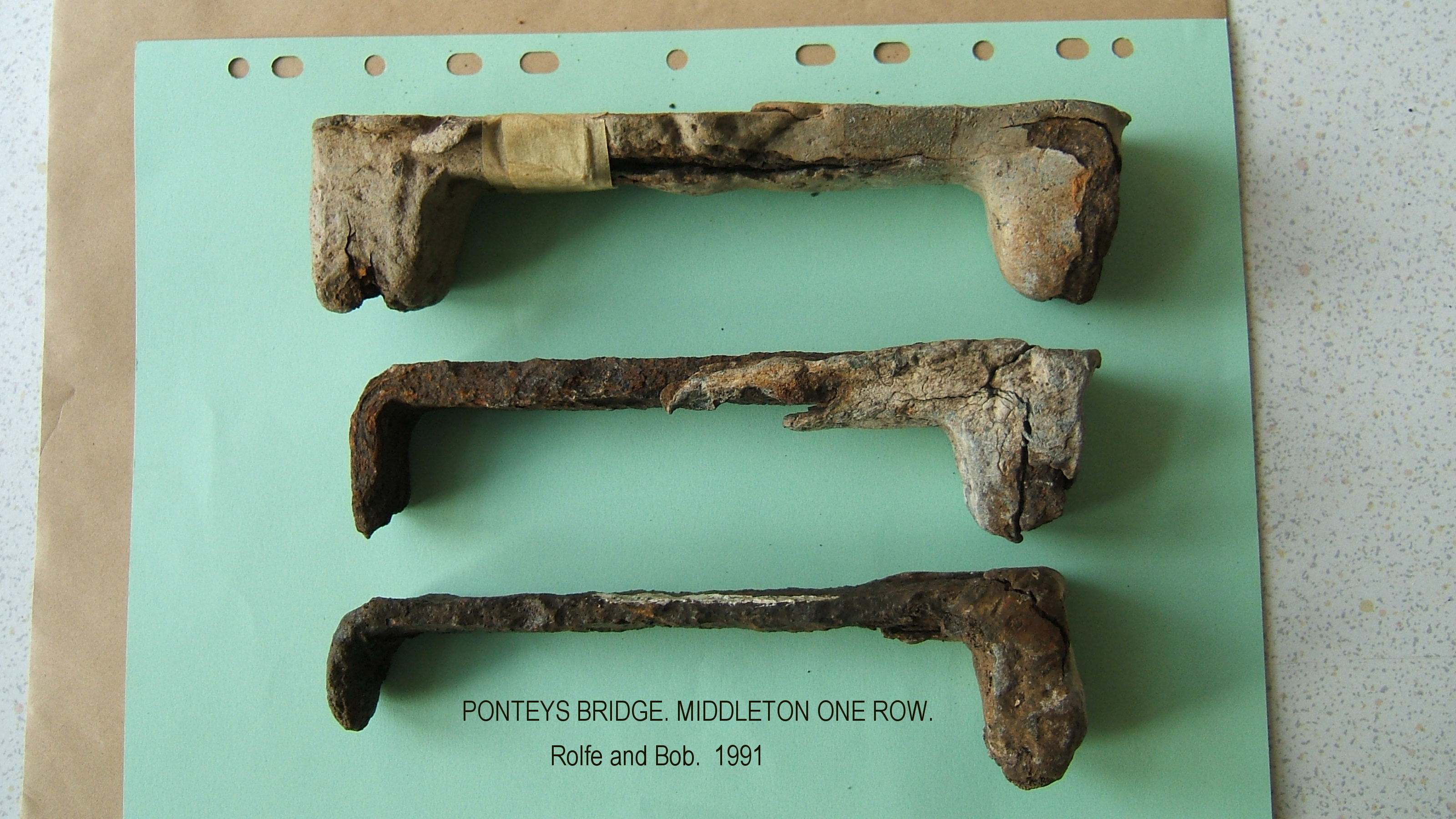
Our first dive was on the 4th May 1991, when we spent 5 hours searching approximately 100m of river bed. We knew we were in the right area when we found pieces of worked lead, followed by a chisel, then an iron clamp, clamps of this type were used to hold massive bridge stonework together, the lead was then poured in molten solidifying the joint between the iron clamp and the stone. The lead would be chipped out with a chisel when the bridge was being dismantled.
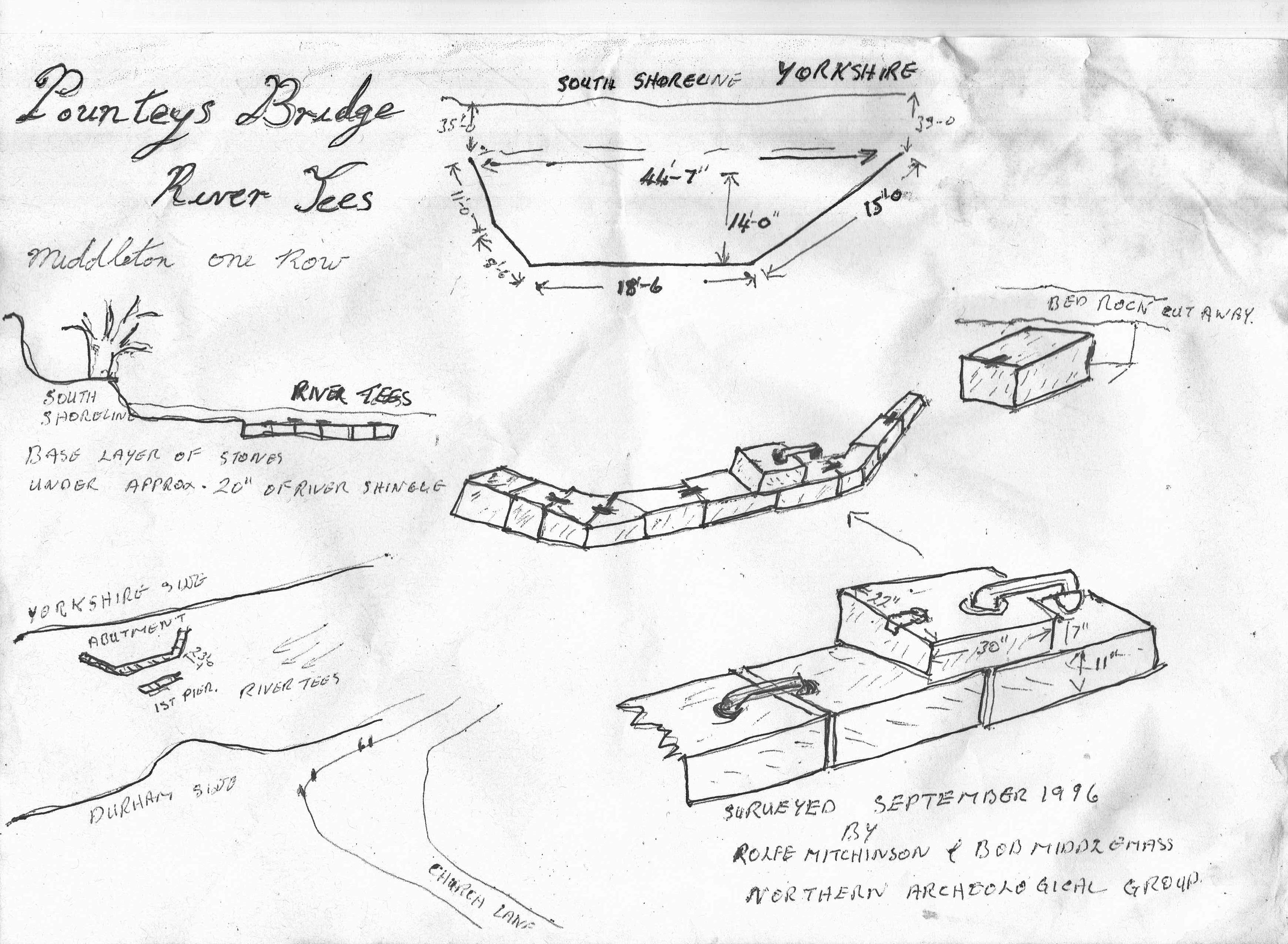
Ponteys Bridge stone clamps
Our next dive on the 8th June 1991 produced a second iron clamp, and after digging down 300mm in the gravel bed adjacent to the southern bank, we uncovered the top of a large worked stone. This stone measured 550mm D x 750mm W x 175 mm H. We were happy we had now located the remains of the southern abutment of Pountey’s Bridge, but were pleasantly surprised to discover that there was another layer of clamped foundation stones underneath this single stone.
Our next job was to find a pier, so we measured out 8m from the face of the abutment and dug down into the gravel. After digging 450mm down, the stonework of the likely pier emerged with quite an area of it still intact. The huge stones like the abutment were held together with iron clamps.
Over the next few weeks we completely uncovered the south abutment and found it to be 13.6m wide and 15m deep.
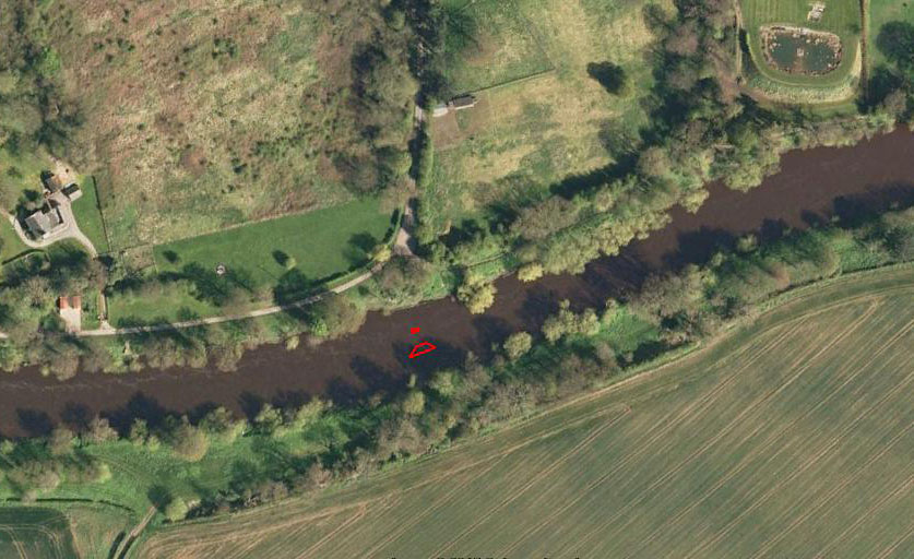
Ponteys Bridge site planLocation of Ponteys Bridge south abutment and pier adjacent to Church Lane, Middleton One Row
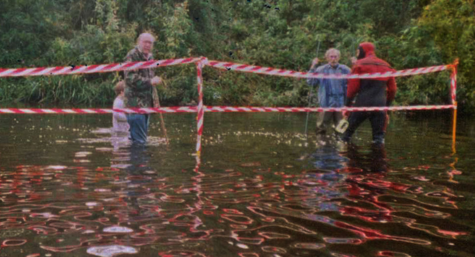
An open day was held in the September 1991, when members of our Northern Archaeology Group and the public, were able to wade across the warm river and observe the foundations, using glass bottom buckets.
Ponteys Bridge 1991 Public Open Day
After the open day, Bob and I reluctantly filled the excavations in and the bridge resumed its long sleep.
Bob and I have recovered approximately 5000 Roman coins and artefacts, plus buckets of pottery from the Roman bridge crossing at Piercebridge, in contrast we have not managed to find a single coin, artefact, or shard of pottery at Pountey’s of any period. This absence of material may be more a factor of the deep deposits of river gravels 2-3 metres deep across the Pountey’s crossing site, perhaps in the future investigating down to the the bedrock, the secret past of Pountey’s Bridge will probably be found.
The investigation whilst perhaps not confirming whether the bridge was Roman not, has perhaps provided additional evidence supporting a likely medieval date for the bridge . Traditional Roman masonry construction techniques used in large structures are alternating stretcher courses and header courses, this has the purpose of the header courses extending behind the facing stone, locking the stone face of the structure to the core structure behind, and increasing the stability of the structure as a whole. However the two courses of masonry exposed in the south abutment of Pountey’s are both stretcher courses, there is also the absence of Lewis holes in the stones for location and handling the material, also very unusual though not unknown on a Roman structure. Pountey’s Bridge was a mystery, and to some degree still remains a mystery, although we have perhaps shed some light on the issue.
Rolfe Mitchinson & Bob Middlemas.
Postscript.
Although this site is principally for research conducted by the Mid Tees Research Project, we are happy to publish other unpublished research by other organisations or individuals. If you have a piece of work gathering dust on your shelves, send us a copy either peer reviewed or not, and we will add it to the archive. It is more important that raw data is made available to other researchers, even if some of the ‘T”s and a few of the ‘I’s remain uncrossed or undotted.
Please send any contributions to: john.brown@reiverenglish.com
On the 13th December 2014, I gave a talk at Thornton le Street as part of a series of talks promoting current and proposed research into the Roman Roads of North Yorkshire.
My talk was the last in the first series of four which had all been well attended. My talk to my surprise got over 70 people paying to attend, suggesting the potential for amateur archaeological endeavour in North Yorkshire is waiting to be tapped.
The talks were organised by John Sheehan, well known to the archaeological community in the region, and who has been leading a proposal to carry out investigations into potential Roman archaeology along the alignment of Cades Road ( Margary 80a), on its route through the Thirsk/ Northallerton area.
Fieldwork and geophysical survey are on the cards in the next few months, as are a further series of talks, anybody who might be interested in attending or taking part, can contact John at: