On Saturday the 5th December 2015, the Teesside Archaeological Society hosts the annual Elgee Memorial lecture at the Dorman Museum, Middlesbrough between 1000 and 1200. A registration link is available at the bottom of this post.
“The Rise and Fall of the Late Iron Age Royal Centre at Stanwick, North Yorkshire with Professor Colin Haselgrove (University of Leicester).
The enormous earthwork complex at Stanwick, west of Darlington—enclosing nearly three square kilometres—is the largest continuous prehistoric fortification in Britain, comparable to some of the most important late Age settlements in continental Europe.
In this lecture Professor Haselgrove will present new interpretations based upon excavations by Durham University in the 1980’s and research that has taken place over the past 25 years. Radiocarbon dating shows that Stanwick was occupied from the early 1st century BC. The early settlement differed little from others in the Tees valley, but soon after 50 BC, the site was reorganised and fortified, and successive monumental timber structures were built. Imports from other parts of Britain and the continent imply that well before the Roman invasion, Stanwick had attained a similar level of importance to known royal centres elsewhere in Britain and Ireland.
Soon after in AD 43, Cartimandua, the ruler of the Brigantes, entered into a treaty with the invaders. Many unusual Roman goods dating to this period recovered in the excavations must have been gifts showered on the queen, whose residence Stanwick surely was, and the massive perimeter earthwork was constructed in a display of her prestige. However, her rule over the Brigantes did not last. In AD 69, after a rebellion led by Venutius, her estranged consort, Cartimandua sought the protection of the Romans. They quickly set about the permanent conquest of the region—and Stanwick was abandoned.
As well as illuminating the social and political dynamics of the period, the research has cast new light on the everyday lives of the Iron Age inhabitants of the Tees Valley and their ritual and mortuary practices, some of which were continued by the agricultural population of the area in the Roman period. ”
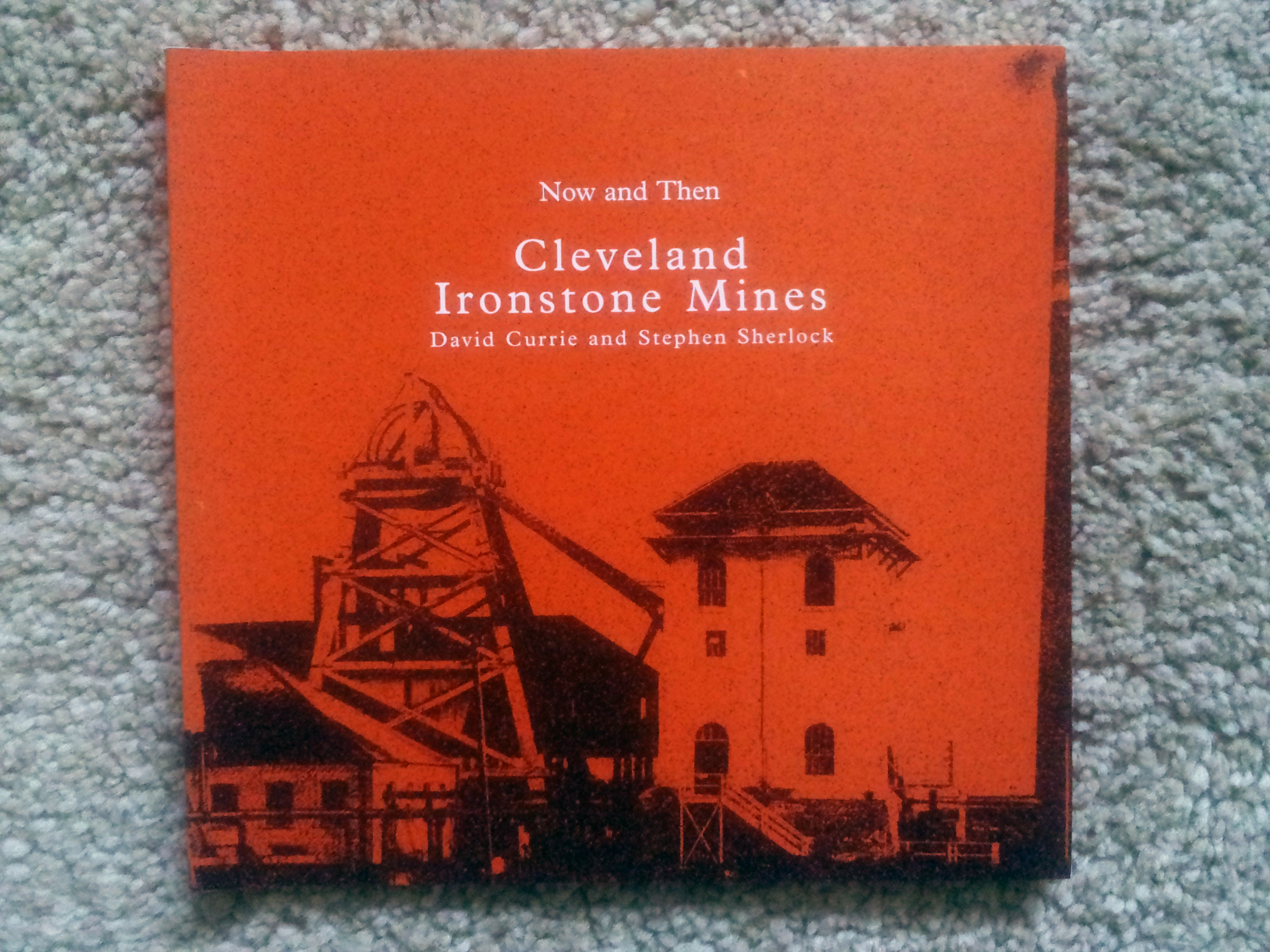
Now and Then Cleveland Ironstone Mines David Currie and Stephen Sherlock
Considerable numbers of self funded publications in local history and archaeology are published every year, yet rarely see the light of day outside of the community that produced them.
Many of these publications are of great interest, sell out and recoup their costs, but many others don’t, and end up in a cardboard box in somebodies wardrobe.
This work deserves a wider circulation, hence our decision to offer this service. We will be happy to advertise any remainder copies on our site for sale , or any used out of print publications in good condition.
The price and postage cost is to be determined by the vendor, and the despatch of the product to the customer is also the responsiblity of the vendor. Our role is simply to act as a window for the publication to be offered for sale , and complete the purchase using our Paypal account. The only charge will be on the sale of an item for which we will make a charge of 15% of the purchase price, all proceeds will be used to support our work on the Mid Tees Research Project.
The first publication we will be offering shortly is pictured above. Published in 1996 the book on Cleveland Ironstone Mines is 74 pages long, the remainder copies have been languishing in my wardrobe for years.
Please contact me if you have any books you want to offer for sale.
I was first attracted to archaeology in the late 1980’s with my brother Graham, but for the life of me I can’t remember what attracted me to the subject in the first place. I probably followed the same route as many. An interest in history, initially a number of evening classes led by Cleveland County Archaeology Unit, before completing a Diploma in British Archaeology at the University of Leeds in the early 90’s.
I joined the Teesside Archaeological Society and volunteered to set up a fieldwork group, whereas I was enthusiastically co-erced onto the committee, shortly afterwards to be ‘promoted’ to serve also as secretary for a number of years.
I established the Mid Tees Project to look at the neglected Roman period in the Tees valley, especially the significance and role of Cades road, and carried out a number of investigations, including investigating and establishing the Roman villa at Dalton on Tees as a classic developed villa, moving the extent of the villa landscape north to the Tees.
Ding dong bell, Brownie’s down a Roman well.
In 1999 I gave an impromptu talk on one of my pet areas of interest geophysics, to the Council for Independent Archaeology at their Sheffield congress on ‘Demystifying Archaeology’, after all three speakers pulled out. It is refreshing to see that the CIA from those early tentitive steps now produce the budget TR/CIA resistivity meter which has 100 units carrying out valuable amateur archaeology.
In the real economy I am a communications and electronics specialist, and have a particular interest in the use of technology in archaeology, especially in the geophysical survey area, My working life however has switched between running my own business locally, and employment maintaining national communication infrastructures, this coupled with the needs of a growing family resulted in limited opportunities to conduct research. After 1999 there was an 11 year gap in my archaeology due to work and other pressures, before returning to archaeology in 2010. In the intervening years the Mid Tees Project went into a long slumber, as the principal (me) left the scene. On returning to archaeology and waking up the project, I have made it incumbent that in future there should be no single principal , but a co-operative project to ensure project continuation. My first port of call for leaders for the project were Jenny Parker and Linda Davies from the early days.
I have from the beginning always considered myself an amateur archaeologist, who spurns conventional thinking and established theories, in preference for original research and fieldwork. A key focus of my work has always been the promotion and extension of traditional amateur archaeology , which since the early 1990’s has been under threat.
Although the instigator of the project, I principally manage the landscape research and geophysical investigations of our survey area, whilst also maintaining and writing this blog, and occasionally sticking a shovel in the ground when the urge takes me.
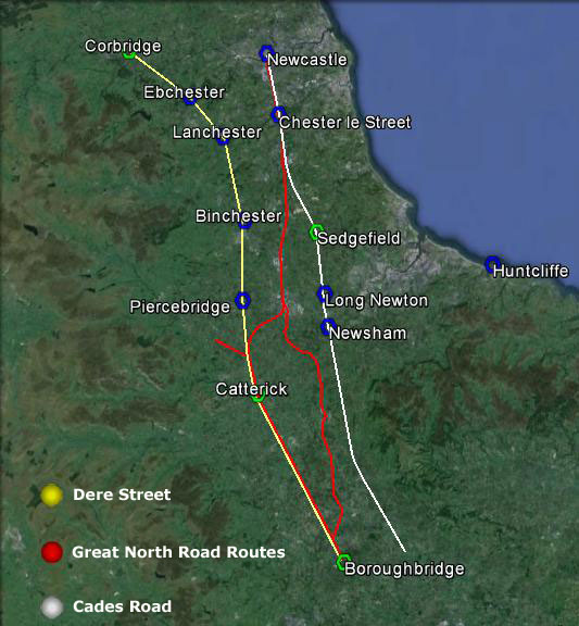
A major part of our project is understanding the significance of Cades Road(Margary 80a), the eastern twin of Dere Street running north/south through the Vale of York.
Often in focusing on a defined historical period for research, it is easy to become out of sync with that which went before and after. Most will have heard the urban myth of the A1 being on top of Dere Street on its route through North Yorkshire and Durham, but is that actually true.
The Roman road Dere street is a Roman military road hugging the eastern side of the Pennines through our research area, transecting the entrances to the upper Yorkshire and Durham Dales.
After leaving Catterick on the Swale and passing Scotch Corner the start of the east/west route across the Pennines, Dere St leaves the alignment of the modern A1, and slowly begins its climb to an elevation of upto 260m as it moves increasingly west.
The road connects a series of Roman forts in west Durham, Piercebridge on the Tees, Binchester on the Wear, Lanchester on the Browney, Ebchester on the Wear, arriving at the major Roman supply depot at Corbridge on the Tyne, centrally positioned to supply forts on Hadrians Wall both to the west and east. Was it built to create a line of forts, controlling the high Pennines, or to protect a strategic supply route. Perhaps in reality it was a bit of both.
Dere St- Great North Road- Cades Road
It would appear once its military purpose ended in the early 5th century, whilst probably remaining in use as west Durham local road, the next time we see the road as a published route in the medieval period, where it is recorded only as a route to Scotch Corner for access to the east west route across the Pennines.
To the north of Scotch Corner,, the focus of medieval settlement is in the productive lowland areas and coastal plains, and the strategic routes followed. On a purely practical level as a strategic route, the course of Dere Street in Durham was always a road to knowhere, once Hadrians Wall went out of use, subject even today to winter inaccesibility, and once north of Hadrians Wall a journey to Scotland would have required navigating across the equally inhospitable and at times inaccessible high Cheviot border country.
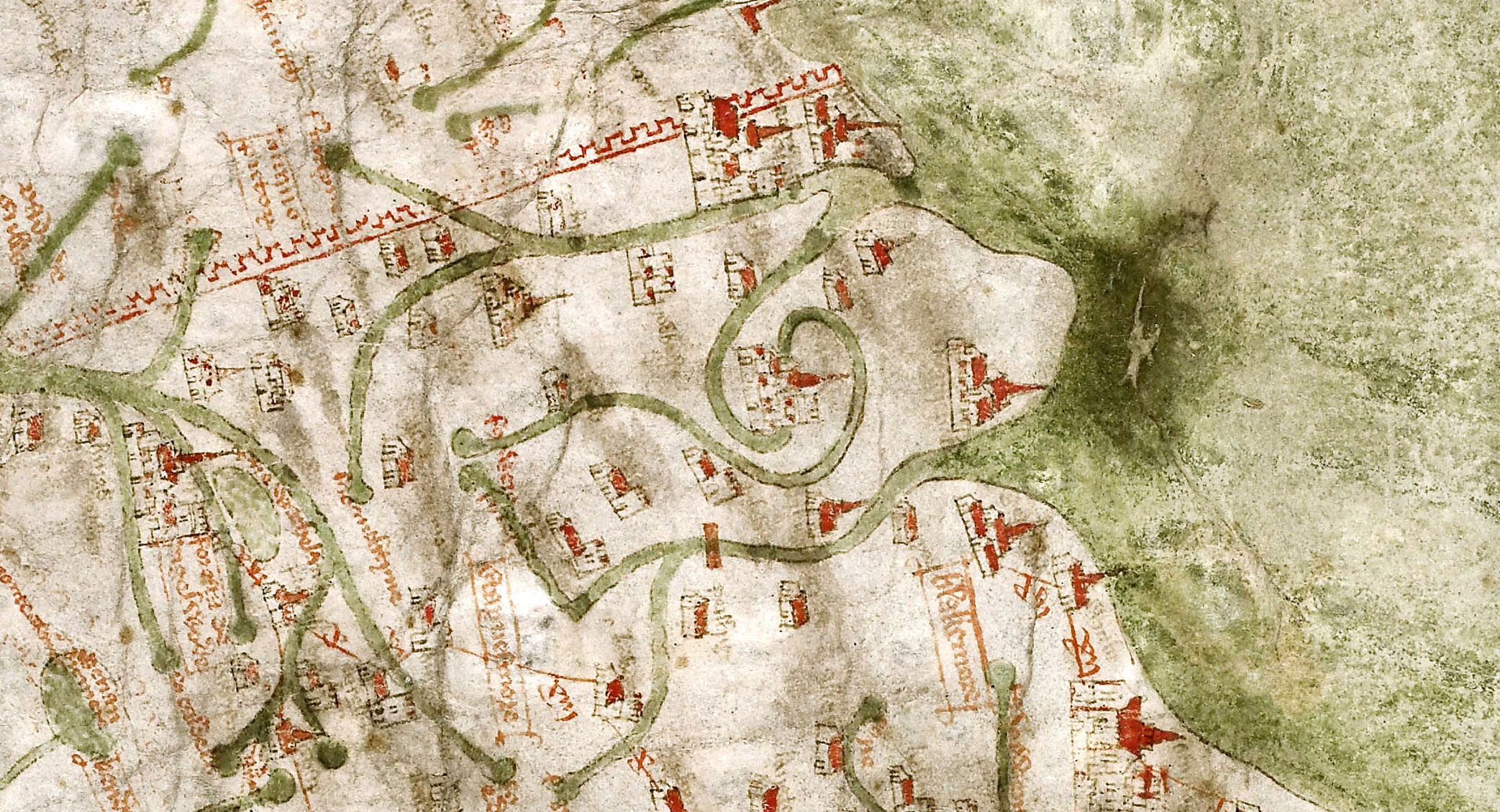
Gough Map 1360
What is interesting is that if we take the Yorkshire stretch of Dere Street, and the Durham stretch of Cades road, join them with a wibbly wobbly bit of the Great North Road, and we end up with the A1 route pre-motorway upgrades
I would now like to introduce an excellent piece of unpublished research on the Great North Road by Hugh Gillespie.
I bumped into his website by accident which has a selection of chapters available online to read. I approached Hugh who kindly provided me with the chapters relating to Yorkshire and Durham, and gave me permission to publish them on the blog. They offer a fascinating insight into the development of the modern road system. Of particular interest to me is the reality that the link between Dere Street the Great North Road and the A 1 is quite recent in historical terms, contrary to what many of us believe, as recently as the 1920’s when the road system was named, the road we know as the A167 Topcliffe to Darlington road through Croft was actually designated the A1 for two years before it was transferred to Leeming Lane which we know today as the A1.
Can you hand on heart say that you have ever read cover to cover all those archaeological reports that you have accumulated on your bookshelves over the years, all those shiny volumes bought enthusiastically at your local society events, dayschool’s and conferences. Are they essential bedtime reading, or simply gathering dust between the Book on National Trust Houses and the RSPB Book on British birds.
I am probably being a slightly unfair. Of course you have probably looked at the colour pictures of the key finds, probably read the introduction to the site, and even perhaps the conclusions, but have you really read the chapter that has 50 drawings of assorted shaped post-holes, have you really read the wordy analysis of those three cruddy pottery finds, or the section on that xrayed lump of corrosion deposit that once might have been a nail . I hope not, or I fear for your sanity.
An archaeological report published at great expense in both money and time for a production run of 250 or so, is perhaps the most pointless use of resources imaginable. Months and months of work, numerous peer reviews, some specialist reports that are nothing more than an exercise in printed verbiage, all simply to produce a monumental tome to sit aside the equally unread monumental tomes that are so full of if’s but’s and maybe’s that any conclusions they may have arrived at, are out of date practically before the ink is dry.
Nothing more than a massive exercise of ego and profligacy over common sense, especially when the core information could be put into the public domain at a fraction of the cost.
It is at this point that I arrive at the title of this essay… POST-HOLES
Post-holes are the bread and butter of archaeology, to the active imagination they create circles, alignments, ritual activity, all on the basis of a hole in the ground. If you look at any report hours and hours of work is put into drawing them in minute detail, as if millimetre recording will somehow explain their purpose, when the only thing all the hours of work reveals is that it is still just a hole in the ground.
Draw it on a plan , record its width and depth, make a note of any packing stone, take a picture and analyse the deposits if you have the money within it, but why on earth do we need a sectional drawing of a hole probably dug without any particular care, just like holes have been dug in the ground for ever by a man with a shovel.
The reality is post-holes as evidence of a structure are 5% evidence and 95% guesswork. I could plant 4 x 300mm posts to form an 8m square, and build a modern detached house on it, which on having disappeared in a thousand years time would be simply four post- holes in the ground for future archaeologists to wax lyrically over..
The fact is archaeology in the modern world of technology and instant imagery is still clinging to the techniques of the 19th century antiquarians. We live in an information age, it is time we abandoned the cleft stick in the form of large and incredibly expensive publications full of outdated recording techniques that nobody reads, and begin thinning them out to a more readable form, and we could start with leaving out the reams of post-hole drawings, stick to the facts, and dump the generally speculative pie in the sky analysis of their purpose.