
Merry Christmas.
It’s that time of the year again, food, food, food, too much booze, and the yearly repetitive cycle of regurgitated TV from all the broadcasters boring you to distraction.
So here you go, a challenge to you all!!
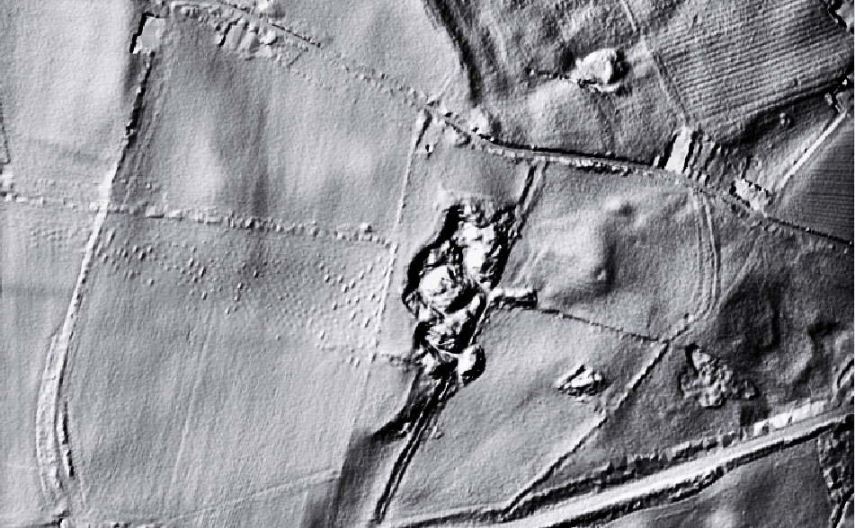
The image is a LIDAR image of a piece of landscape with archaeological features.
The features of potential archaeological interest on the image are unknown to archaeology, spanking brand new finds.
Archaeology of course has a habit of finding two stones and calling it a wall, 3 stones and calling it an alignment, making the evidence fit the established narrative is the bread and butter of archaeology. Can you can see something you think you can identify on the image, do the characteristics fit into any particular time period, what might its likely purpose be if found in a given location etc, etc, etc.
The presented image is not a photograph, but a LIDAR image. For those not familiar with LIDAR, it is an aerial technique where an aircraft flies over the landscape emitting a laser beam toward the earth, which bounces of the earth and is received back at the aircraft, the time delay for the return signal provides the data to calculate the elevation of the land surface at that point. The technique is used extensively to locate pinch points in watersheds which may cause flooding, and other environmental and agricultural analysis.
For archaeology it is particularly useful for its ability to record very low earthworks that are not visible in aerial photography, and for penetrating vegetation cover to see the profile of the ground surface underneath. There are a number of different LIDAR techniques, the one used on the image is Digital Terrain Mapping which has the effect of flattening features. For archaeological purposes to get the best out of the image it needs to be further processed using an image editing software applying filters to give the image a 3D effect.
The image covers an area 750m x 450m, the black splodge in the middle is a worked out quarry, the highest point is is 196m OD, and it is north of York and south of Newcastle. and that is your lot.
There is no prize for getting it spot on, apart from the cache of knowing that when it comes to locating this type or archaeology, you know your onions.
Don’t be shy have a pop at it, either on the blog comments or mail me at:
john.brown@reiverenglish.com