
A major part of our project is understanding the significance of Cades Road(Margary 80a), the eastern twin of Dere Street running north/south through the Vale of York.
Often in focusing on a defined historical period for research, it is easy to become out of sync with that which went before and after. Most will have heard the urban myth of the A1 being on top of Dere Street on its route through North Yorkshire and Durham, but is that actually true.
The Roman road Dere street is a Roman military road hugging the eastern side of the Pennines through our research area, transecting the entrances to the upper Yorkshire and Durham Dales.
After leaving Catterick on the Swale and passing Scotch Corner the start of the east/west route across the Pennines, Dere St leaves the alignment of the modern A1, and slowly begins its climb to an elevation of upto 260m as it moves increasingly west.
The road connects a series of Roman forts in west Durham, Piercebridge on the Tees, Binchester on the Wear, Lanchester on the Browney, Ebchester on the Wear, arriving at the major Roman supply depot at Corbridge on the Tyne, centrally positioned to supply forts on Hadrians Wall both to the west and east. Was it built to create a line of forts, controlling the high Pennines, or to protect a strategic supply route. Perhaps in reality it was a bit of both.
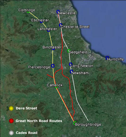
It would appear once its military purpose ended in the early 5th century, whilst probably remaining in use as west Durham local road, the next time we see the road as a published route in the medieval period, where it is recorded only as a route to Scotch Corner for access to the east west route across the Pennines.
To the north of Scotch Corner,, the focus of medieval settlement is in the productive lowland areas and coastal plains, and the strategic routes followed. On a purely practical level as a strategic route, the course of Dere Street in Durham was always a road to knowhere, once Hadrians Wall went out of use, subject even today to winter inaccesibility, and once north of Hadrians Wall a journey to Scotland would have required navigating across the equally inhospitable and at times inaccessible high Cheviot border country.
What is interesting is that if we take the Yorkshire stretch of Dere Street, and the Durham stretch of Cades road, join them with a wibbly wobbly bit of the Great North Road, and we end up with the A1 route pre-motorway upgrades
I would now like to introduce an excellent piece of unpublished research on the Great North Road by Hugh Gillespie.
The Great North Road (H R Gillespie)
I bumped into his website by accident which has a selection of chapters available online to read. I approached Hugh who kindly provided me with the chapters relating to Yorkshire and Durham, and gave me permission to publish them on the blog. They offer a fascinating insight into the development of the modern road system. Of particular interest to me is the reality that the link between Dere Street the Great North Road and the A 1 is quite recent in historical terms, contrary to what many of us believe, as recently as the 1920’s when the road system was named, the road we know as the A167 Topcliffe to Darlington road through Croft was actually designated the A1 for two years before it was transferred to Leeming Lane which we know today as the A1.
Fascinating reading, cracking research,
Thanks again to Hugh.
Great North Road History 1. Chapter 1
Great North Road 2, Chapter 7 (Doncaster to York by eastern route)
Great North Road 2, Chapter 8 (York to Northallerton)
Great North Road 2. Chapter 9 ( Doncaster to York by eastern route)
Great North Road 2.Chapter 10 ( Brotherton to Northallerton)
Great North Road 2, Chapter 11 ( Northallerton to Darlington)
Great North Road 2.Chapter 12 ( Boroughbridge to Darlington via Scotch Corner)